
Less Crowded Hikes in Glacier National Park - East Side
The east side of Glacier National Park is well known for its scenic hiking trails with thousands of visitors venturing to Grinnell Glacier, Iceberg Lake and Ptarmigan Tunnel each summer. Those hikes are beloved for good reason but the park features over 700 miles of trails, many of which fly under the radar of those who visit the east side. With much needed road construction into Many Glacier slated to commence in June 2020, we are highlighting some less utilized but still awesome hiking options to consider in your summer plans. The following hikes don’t require you to drive through the Many Glacier, St. Mary or Two Medicine park entrances though we encourage you to purchase your park pass ahead of time by visiting the recreation.gov website.
Lee Ridge Hike
Mileage: 11.8 / Elevation Gain: 2,094 feet / Elevation Loss: 144 feet
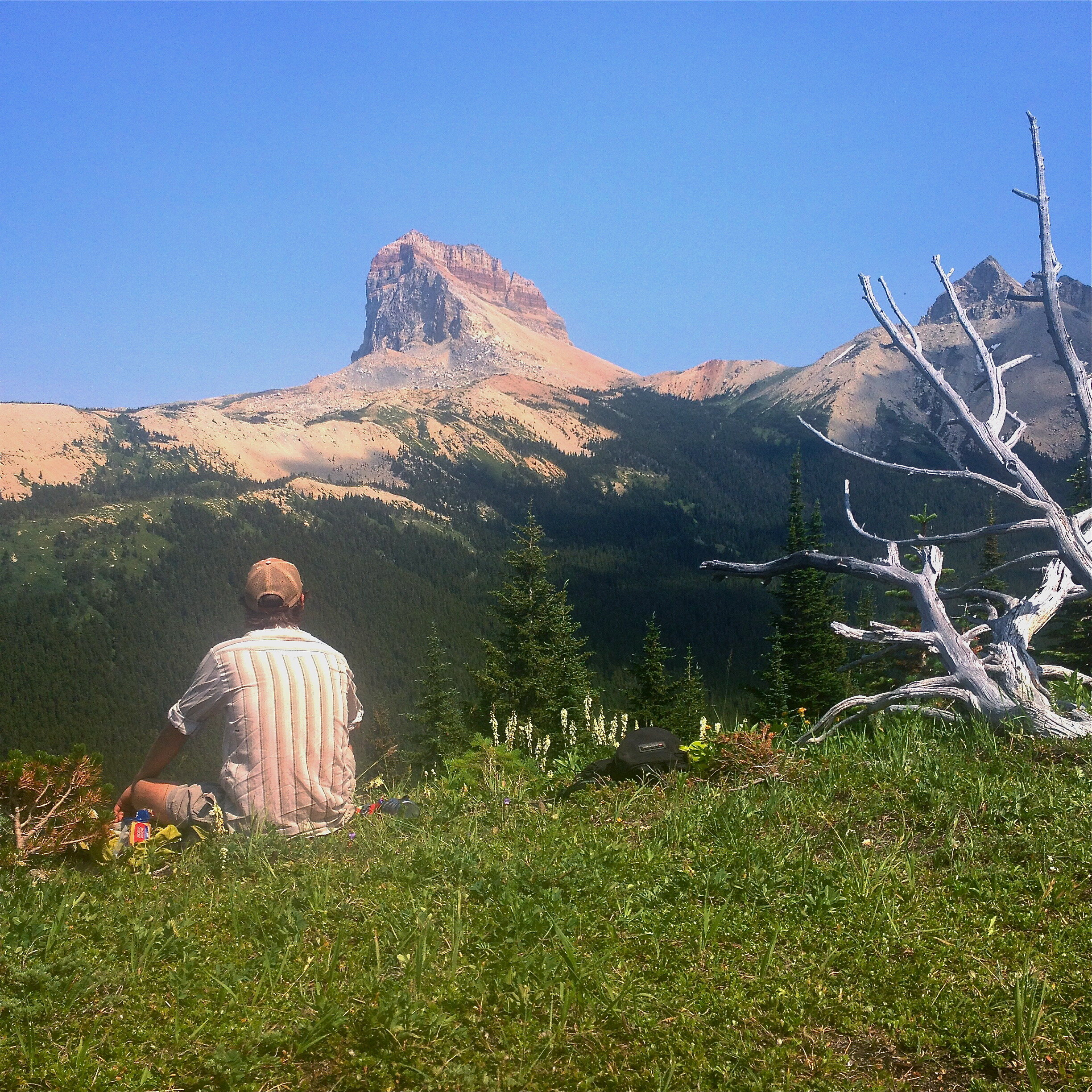
Taking in the view of Chief Mountain from Lee Ridge in Glacier National Park
Just short of the Canadian border, Lee Ridge rewards you with unique vantages of Chief & Gable Mountains and sweeping views of the remote Belly River drainage. The incredible views found toward the end of the hike are worth the first few miles of moderate elevation gain through a pine forest. The large sections of shaded trail can make this a great hike for warmer days. For detailed trail information, visit hike734.com.
Directions: From Babb, travel north on Hwy 89 for approximately four miles. Turn left onto Hwy 17 (Chief Mountain Hwy) and drive for approximately 13 more miles. The trail head is located on the southern side of the road and you can find parking in a nearby turnout across the highway, approximately 150 yards to the north. There is a sign by the turnout that reads “Customs 1/2 Mile Ahead.”
Belly River Ranger Station Hike
Mileage: 12.2 round trip / Elevation Gain: 277 feet / Elevation Loss: 923 feet

Approaching the Belly River Ranger Station in Glacier National Park. Photo credit: Charlie Stone
If you like your adventure with a side of history, this hike is for you. The hike begins by descending through a forest of lodgepole pine into the Belly River Valley, where you’ll enjoy walking through alpine meadows dotted with aspen and evergreen. The sounds of the Belly River will accompany breathtaking views of the surrounding mountains as you wind your way toward the ranger station. Constructed between 1925 & 1926, the Belly River Ranger station is one of the oldest continually manned ranger stations in the park and the only one accessible by trail alone. For more history on one of the ranger station’s most notorious inhabitants, check out our blog on the infamous Joe Cosley. Keep in mind that most of the hard work on this hike takes place on the way back where in the final mile you have to ascend approximately 900 feet back to the trailhead. For detailed trail information, visit hikinginglacier.com.
Directions: From Babb, travel north on Hwy 89 for approximately four miles. Turn left onto Hwy 17 (Chief Mountain Hwy) and drive for approximately 14 more miles. Immediately before reaching the Canadian border crossing, the Belly River Trailhead parking area will be on your left. It has a decent amount of parking available but also serves many backcountry campgrounds. As always, an early start is recommended.
Red Eagle Lake Hike
Mileage: 16.2 round trip / Elevation Gain: 809 feet / Elevation Loss: 593 feet
On your way to Red Eagle Lake, you’ll stroll past the shores of upper St. Mary Lake, venture through alpine meadows and the burned remnants of the 2006 Red Eagle Fire, all while taking in views of the striking St. Mary Valley. Known for an abundance of wildflowers, berries and wildlife, the Red Eagle Lake trail provides ample photo opportunities and picturesque spots for lunch. This route is a lengthier option for a day hike but gradual elevation gain and loss mitigate the difficulty. For detailed trail information, visit hikingproject.com.
Directions: From St. Mary, take the turn for the Going-to-the-Sun Road and proceed past the St. Mary Lodge. Shortly before the St. Mary Visitor Center, turn left and follow the signs for the 1913 Ranger Station. The parking area and trailhead are located just below the historic ranger station.
Beaver Pond Loop Hike
Mileage: 3.6 round trip / Elevation Gain: 350 feet

Beaver Pond Loop Hike in Glacier National Park
This leisurely loop is a great hike for kids and those new to hiking. While on the shorter side, the trail still provides a variety of terrain to experience including alpine meadows, old growth forest and the charred remnants of the 2006 Red Eagle Fire. Incredible views of the St. Mary Valley can be enjoyed throughout much of the hike. We prefer to start the loop by heading toward the historic 1913 Ranger Station and getting most of the small elevation gain out of the way at the start. For detailed trail information, visit hikinginglacier.com
Directions: From St. Mary, take the turn for the Going-to-the-Sun Road and proceed past the St. Mary Lodge. Shortly before the St. Mary Visitor Center, turn left and follow the signs for the 1913 Ranger Station. The parking area and trailhead are located just below the historic ranger station.
Medicine Grizzly Lake
Mileage: 12.4 round trip / Elevation Gain: 625 feet

Abundant wildflowers in Glacier National Park
Originating from the often overlooked Cut Bank area of the park, the hike to Medicine Grizzly Lake is a great choice for avoiding crowds. The trail winds through vast meadows intertwined with conifer stands as Mad Wolf and Bad Marriage mountains rise above you to the south. The lake itself resides in a large basin below the Continental Divide, with the notable Triple Divide Peak situated to the northwest. This trail is well known for wildlife frequenting as well as an abundance of wildflowers and berries. For detailed trail information, visit hikinginglacier.com.
Directions: From St. Mary, drive approximately 14 miles south on Hwy 89. Turn right onto the gravel road leading toward the Cut Bank campground. The gravel road will continue for five miles and you will reach the parking area just past the park ranger quarters. Start the trail from the Pitamakan Pass trailhead.
Firebrand Pass
Mileage: 12.4 roundtrip / Elevation Gain: 1950 feet

View from the summit of Calf Robe Mountain.
Starting out approximately six miles past East Glacier off of Hwy 2, the trail to Firebrand Pass ventures into the southern side of Glacier. The route will take you through open meadows and thick aspen stands before climbing toward the saddle between Calf Robe and Red Crow mountains. Along with providing outstanding views, Firebrand Pass is also known for being particularly windy - plan accordingly! For more trail information and to take advantage of their guiding services, visit Glacier Guide’s website.
Directions: From East Glacier, travel southwest on Hwy 2 for approximately six miles. The parking area is located across the highway from mile marker 203. You’ll begin from the Lubec trailhead located across the railroad tracks.
For general information on hiking in Glacier National Park including maps, trail statuses and wildlife precautions, visit the NPS website.
Want to go with a guide? Contact Glacier Guides, the park's hiking partner since 1983.